PrecisionFlight 2.0 is available for download!
“PrecisionFlight 2.0 helps pilots to achieve robust, reliable, and repeatable data collection with their DJI drones. Now, pilots have access to the advanced mission planning and sensing capabilities necessary to meet the growing demands of aerial intelligence. Paired with PrecisionMapper, it’s easier than ever to go from flights to insights.” - Ricky Hopper, PrecisionHawk Technical Lead
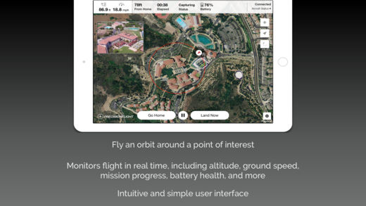
New and improved features include:
- Orbit Missions: In just a couple steps, collect data to generate high-quality 3D models of tall structures, like buildings or towers.
- Thermal (Zenmuse XT) Support: Use thermal sensing in a broad range of applications, such as finding hot spots in solar arrays, locating leaks in roofs, or assessing plant health. Capture thermal imagery at a resolution that ensures accurate stitching and data outcomes.
- Advanced Camera and Mission Settings: Take full control of your aircraft and camera. Use optimized camera presets to capture high-quality data in a variety conditions.
- Redesigned UI: Get instant feedback on how your inputs impact flights and data collection.
- Import KML Files: Predefine your areas of interest, upload them, and fly.
Apple: https://itunes.apple.com/us/app/precisionflight-for-dji/id1112592228?mt=8
Google Play: https://play.google.com/store/apps/details?id=com.precisionhawk.inflightmobile&hl=en
P.S. To all the PrecisionFlight users who shared their feedback: thank you! We couldn’t pioneer drone-based data collection without your support.