Technology in farming is constantly evolving. Collecting accurate, reliable georeferenced (location in terms of GPS coordinates) data is essential to capitalise on technologies such as variable rate application of chemicals and fertiliser and aid in crop monitoring at a level once not imagined. Some current forms of collecting georeferenced paddock data include:
- Combine harvester – yield maps (crop yield as harvester works through paddock)
- Satellite imagery – colour and near infrared (NIR) bands to produce natural images & vegetation indices such as Normalised Difference Vegetation Index (NDVI)
- Aerial imagery – similar to satellite but offers higher resolution at higher price & some other sensor options
- Tractor – Greenseeker (plant biomass), digital elevation model (DEM) collected from high accuracy GPS
- Utility vehicles e.g. Soil sampling pH & nutrition, electromagnetic conductivity, Greenseeker, DEM
- Handheld with GPS – Greenseeker, soil sampling
- Stationary – moisture probe, weather station
Unmanned Aerial Vehicles (UAVs) are emerging as a cost effective way to collect data with many advantages over the traditional forms listed above. UAVs are as the name suggests an unmanned vehicle which flies over the paddock to collect data. These machines are generally compact, can be cheap, mechanically simple, fly below cloud cover and are on there way to being easy to operate with advanced autopilot systems.
Over the last 6 months I have begun researching civilian UAVs and their application in agriculture as part of my Nuffield Scholarship. Furthermore, I have been testing a budget UAV platform which I will discuss in a later post. The aim of this post is to aggregate key information and ideas on the topic into one space. It is by no means comprehensive – more of a beginning. Note that I am not a pilot or lawyer. This article is general in nature and does not give permission to fly or legal advice. Lets start with a sky-high view.
The Agricultural UAV Solution
It is important to consider all aspects pertaining to the agricultural UAV (aUAV) Solution which I define as a robust, timely, cost effective way to collect usable data to improve yields and overall profitability in sustainable farming systems. Consider the following formula:
aUAV Solution = platform + GPS + autopilot & communication + sensor + data processing & integration + legal & operation
All components of the formula need to be working well and working together for the product to be successful technology. Now enough of inventing acronyms and formulas that will inevitably change, it’s time to flesh out the components of the aUAV Solution.
Platforms
There are two main platforms available: fixed wing and multi-rotor. A fixed wing platform has the advantage of covering large areas efficiently, whereas a multirotor shines in being able to remain very stable in challenging conditions with large payloads.
Due to the scale of broadacre grain growing in Australia, my interest lies predominately with the fixed wing platform type, as paddocks often exceed 250ha (~620ac). ConservationDrones has an excellent list of budget fixed wing platforms they have used as an example.
GPS
Global Positioning Systems (GPS) are the backbone of most spatial technologies. GPS on the UAV tells the autopilot where it is at all times. In addition, GPS links the data collected to it’s spatial position (aka geo-referencing).
Many UAVs are equipped with a u-blox GPS receiver or similar which is compact and provides <5m horizontal accuracy. These systems are affordable and are accurate for most situations.
An exciting development is the Piksi by Swift Navigation, which is a low cost Real Time Kinetic (RTK) GPS receiver that promises to sell for around $1000 which is unheard of in the world of GPS. The Piksi offers centimetre level accuracy inside a compact design ideal for small UAVs. The improved accuracy will be invaluable for autonomous landings and improved accuracy of geo-referencing data.
Autopilot
We are seeing UAV autopilots improve very quickly with increased reliability, especially within the open source community. Autopilots are essential for being able to effortlessly fly over a whole area to collect the desired data. DIY Drones‘ APM:Plane is often the autopilot of choice for hobbyists and entry to mid level platforms. It uses the same hardware and similar software to the APM:Rover I built last year.
There are several other autopilots available, commercial and open source, that are worth checking out. Google it.
Usually the UAV is communicating with a ground control station (GCS) via radio link. GCS is usually just a laptop computer with software such as Mission Planner. Mission Planner is also used to set the flight paths for the UAV missions.
Sensors
The most complex part of collecting good data is having the correct sensor. For plant biomass data, the most important spectral range is in the near infrared spectrum. The two most common options include Tetracam ADC Lite built specifically for UAVs or a digital camera modified to capture within this spectrum (MaxMax for example). The latter option is the most cost effective solution. Some preliminary studies show that some good results can be achieved.
Researchers are working hard improving sensors for UAVs. For example, TerraLuma, is a research group at the University of Tasmania. Projects of interest include high accuracy geo-referencing of imagery ‘on the fly’ and the use of a hyperspectral pushbroom scanner to collect data.
Public Lab (an open source community) is also working at modifying cameras similar to MaxMax but also on cheaper devices such as web cams. The recently achieved funding through a Kickstarter campaign. Maybe we will have another cost effective solution soon. See also Pi NoIR.
It is worth mentioning that it is very common for UAVs to have a GoPro camera (or similar) mounted to capture high definition video footage. This video footage is valuable for visually monitoring crops from the sky but is generally not processed to geo-referenced data. There is always exceptions such as shown in this video over a construction site where video footage is used to generate a 3D model.
Data Processing & Integration
Although collecting good data is the most challenging part, the most time consuming (and/or expensive) part can be processing it to a point where it can be integrated into precision agriculture systems. Generally the UAV will follow a lawn mower track collecting an image images at a defined interval with a generous defined overlap. The raw data will usually be images (up to several hundreds – think gigabytes) with a single GPS position and maybe a bearing per image. The challenge for the data processing is to stitch these images together to generate one homogenous data set. Every image is affected by the differing roll, yaw and pitch of the UAV as the image is captured. Some of the more common applications include:
- Drone Mapper is a successful web based startup which effectively filled the affordable yet professional data processing gap
- Agisoft Photoscan
- Pix4D
- Microsoft ICE is a web based and free to use but only stitches images without offering geo-referencing or 3D modelling unlike the above mentioned applications
- VisualSFM, CMVS, and CMPVMS – Flight Riot does the hard work explaining how to use this software to generate a 3D model from digital camera photos. This is probably one of the more complex processes but uses all free(ish) software.
Once a geo-referenced, homogenous, data set over a paddock is achieved it could possibly undergo further post processing to determine NDVI. This raster data may then, for example, be used to define zones for in crop variable rate fertiliser application.
As mentioned, some of the above software is able to create 3D models from 2D photographs. These 3D models could be used to create digital elevation models (DEM) which is valuable in farming for determining water movement.
Legal & Operation
In Australia, the Cival Aviation Safety Authority (CASA) rule the sky. CASA has rules governing the use of UAVs (which they call unmanned aerial systems or UAS) and is in the process of re-evaluating some regulations. See a summary of a recent speech from CASA here.
To operate a UAV/UAS commercially in Australia you need to have a certified operators certificate. A list of those certified is available here.
CASA have done well to have a system set up for UAS. The USA is lagging behind and is just now establishing rules and regulations are UAVs.
Getting into it
There are many companies that are focusing on developing UAVs for the ag industry that fulfill many of the components of the aUAV Solution including AG-Wing, AgEagle and PrecisionHawk. Get your link here.
Edit: See also MarcusUAV
You can buy a calibrated, tested, ready to fly system built from budget readily available components and open source autopilot. For example Event38 and Flight Riot.
The third option is to go fully DIY. I have tried this using a Finwing Penguin fixed wing platform, APM:Plane autopilot, ordinary Canon digital camera as sensor. I am yet to process any images into geo-referenced datasets. I will post more about this soon. Here is an image from one of my first flights.
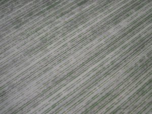
2013/2014 Sorghum from UAV, captured with Canon Powershot D10.
Read the original article here.