

Last year, consulting services firm PwC estimated the market for commercial drone applications could reach $127 billion in 2020*. During this short time frame, multiple industries are predicted to double drone spending.
Early adopters are thinking beyond what they can do now and driving manufacturers to accelerate innovation.
Be prepared for the following hardware advances in the next 3-5 years.
This will result in lighter payloads, fewer flights and streamlined data collection. Thermal sensors with thermal cameras are an example of this consolidation.
Today’s most popular commercial drones can fly 20-30 minutes depending on the weight of the sensor being carried. The current workaround is bringing multiple batteries into the field. However, hybrid solutions—that move away from a reliance on batteries and produce 2-3 hour flight times—are already being used in some cases.
Along with the extension of flight time, advancements in unmanned traffic management and changes in regulations are enabling larger flight radii. In the United States, organizations may earn their Beyond Visual Line of Sight waiver from the FAA.
Advanced sensors will solve specific industry challenges causing niche markets to arise. While still in the early phases, several manufacturers are marketing optical gas imaging technology to the oil and gas industry. This drone-based sensor, which identifies and detects gases such as methane, allows workers to monitor for potentially dangerous leaks from a safe distance.
Today, the flight path on many drones is completely separate from advanced sensor operation. This is problematic because it necessitates workarounds and often some level of custom integration. Advanced sensors and drones will eventually become fully compatible with one another, enabling adoption across the enterprise.
Taking the First Step
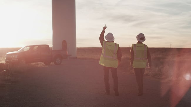
The case studies in this ebook are just a sample of the challenges being overcome by employing drone-based advanced sensing and the range of uses is growing at an accelerated rate.
The data outputs can integrate with your existing technology platforms. If getting started seems overwhelming, consider running a small pilot program to help you gain clarity and prove value.
Find a partner to guide you through an effective test and supply the necessary hardware. Don’t make hardware investments without first getting exposed to the technology in the field.
Once your comfort level increases, you can quickly build a robust program that’s scalable.
Best of all, the data can be secured quickly and without risking employee safety or disrupting operations.
Like those pioneering drone-based advanced remote sensing today, you have the opportunity to change the way your organization collects and uses data to solve problems.
It’s still early: more applications for drone-based advanced sensing are still on the horizon.
Advanced Remote Sensing Services
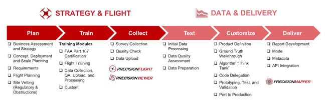
PrecisionHawk’s Advanced Remote Sensing Services are designed and delivered by our in-house experts, including those you’ve heard from in this book.
Here’s how our services work:
A team of industry strategists assess your business and collaborate with in-house regulatory advisers, geospatial scientists, and flight operators to design an approach
Drone flight operators collect data and/or train your team on how to fly
Machine intelligence experts prepare data outputs and run algorithms (or define new ones)
Data and insight are delivered to your organization through turnkey and/or custom-built APIs and reports
Here’s our complete scope of services:
Those mentioned in this eBook include:
- Advanced Remote Sensing
- LiDAR
- Hyperspectral/Multispectral
- Visual, thermal, video, and others
- Beyond Visual Line of Sight (BVLOS) and Expanded Drone Operations and Consulting
Thermal |
Multispectral |
Hyperspectral |
LiDAR |
|
|---|---|---|---|---|
| Type of Data Collected | Relative temperature | Broad spectral data (3-5 bands) | Detailed spectral data (several hundred bands) | Elevation & strucural data |
| Business Uses | Surveillance and security, infrastructure inspections, water source identification, livestock detection and heat signature detection | Instrumental in plant health and management | Plant disease identification, water quality assessment, vegetation index calculations, mineral and surface composition surveys, fill spectral sensing and spectral index research | Create 3D models of man-made structures, topography, maps and measure where vegetation occurs and its density |
| Volume of Data Collected | Gigabytes | Gigabytes | Gigabytes & Terabytes | Gigabytes |
About PrecisionHawk
Founded in 2010, PrecisionHawk helps leaders use aerial intelligence to transform the way business is done. From design and development, to flights, analysis and training—we provide end-to-end support for integrating aerial data and analytics into the enterprise. Our client list includes Fortune 500 companies and market leaders in 150 countries, spanning a range of industries, including agriculture, energy, insurance, government and construction.