UAVs or Unmanned Aerial vehicles are being widely investigated for Emergency Response and Management thanks to their ability to collect reliable and efficient data, fast. Searching and surveying disaster-affected areas, looking for lost persons or determining the safest paths of entry into a disaster site are all use cases that responders have deemed UAV tech to be a helpful asset. While drone is the cool, new tool, what people don’t know, at least most of us, is that there is someone behind the scenes involved in this heroic action – GIS.
In the wake of a serious disaster, Emergency Management Organizations rely on accurate geographic information for virtually all of their emergency response, planning operations, and outreach. Many states across America have their own Geographic Information Systems (GIS) division so that EMO can easily map and access data — from flood zones and local infrastructure to population density and road closures — before, during, and after an emergency.
The Role of GIS in Emergency Response and Management
GIS is a computer system that can associate layers of diverse information, generating products that are much more refined than single map views. By networking maps to databases, GIS enables users to capture, store, manipulate, analyze, manage, and present all types of spatial or geographical data. It is a tool for decision-makers to determine the best position for a new facility, measuring and examining structural or environmental loss, and comparable situations in a neighborhood or city to distinguish a pattern and alike.
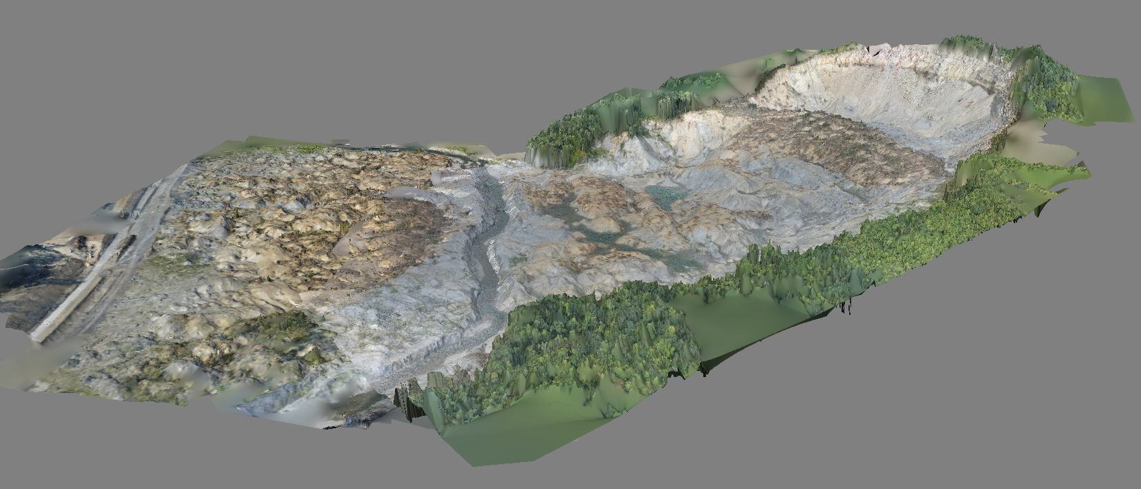 3D model of the
Oso mudslide disaster zone, data collected by PrecisionHawk's
Lancaster UAV and processed by
DataMapper
3D model of the
Oso mudslide disaster zone, data collected by PrecisionHawk's
Lancaster UAV and processed by
DataMapper
For most ER [Emergency Response] planning initiatives, mapping as a preliminary step has proven effective. It all starts with the data. Accurate aerial data sets, collected with a UAV, manned aircraft or satellite imagery, are significant to the success of any operation, with UAVs providing responders with an immediate solution for quick and efficient data collection, on-site, without weather restrictions. Even so, there are many possible ways to generate this information and archive it using some technology applications. Emergency Management Organizations face tremendous difficulties meeting greater demands with fewer resources. Other challenges may involve security, back-up and availability.
While UAV technology allows responders to collect data easier and faster than ever before, the transfer processing and analysis must be properly supported through an aerial data software. PrecsionHawk uses cloud-based software, Data Mapper, for an automated process. Whether you want to know if there are people still inside a building during a fire or to estimate the impact of the disaster on the local population to determine where first-responders should focus rescue efforts, this information are automatically processed without a human touch point.
Disaster and emergency are inevitable, thus, can happen to anyone, anywhere at any time. The key to success in responding to these events will always depend on the awareness of the resources available and the familiarity of its usage. It is an imperative to be ready with tools and applications that can aid boot on the ground to increase safety and efficiently and save lives.
To get more of out of this discussion, join PrecisionHawk at the First Responder/Emergency Management Workshop focused on Unmanned Aircraft Application on 11/19.