For agricultural professionals, such as farmers and agronomists, monitoring the health of crops is an essential component to a successful growing season. But, doing so accurately and with regularity can be tough. Traditional crop scouting methods, such as “walking the field,” can miss early warning signs of plant stress. And analyzing hundreds of acres of fields for health issues is time-consuming.
Fortunately, drone technology enables farmers to quickly capture accurate crop health data over an expansive area. We’ve partnered with BirdsEyeView, an American drone company focused on optimizing drone operations, to make drone-based crop management easier, and faster, than ever.
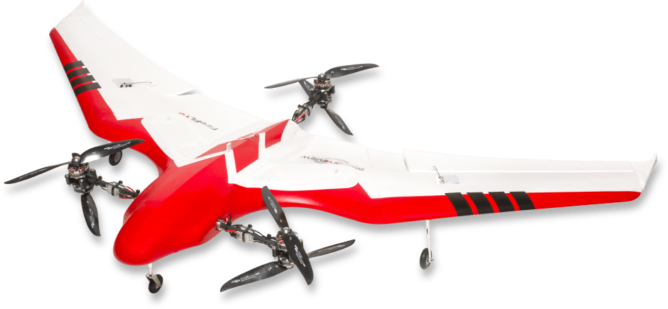
Now available through PrecisionHawk: the FireFLY6 PRO.
Vertical Takeoff and Landing (VTOL) for Safer, More Efficient Deployment
Unlike most fixed-wing drones, the FireFLY6 PRO features pivoting rotors which enable Vertical Takeoff and Landing (VTOL). With the push of a button, the drone automatically takes off vertically and begins forward flight. When it returns for landing, the FireFLY6 PRO hovers over the deployment area and slowly descends to the ground. These vertical takeoffs and landings reduce wear on the drone and decrease the likelihood of a damaging incident.
Furthermore, operators can deploy the FireFLY6 PRO from nearly any location thanks to its VTOL ability. Since the drone requires a deployment area of no more than 10 square feet, finding an area to launch the drone is as easy as pulling off to the side of the road.
Capture More in Fewer Flights
The FireFLY6 PRO’s fixed wing design allows it to fly up to 600 acres in a single flight. That’s greater than most multi-rotor drones. These expansive flights mean operators can save time and money thanks to fewer deployments.
In addition to the FireFLY6 PRO’s expanded coverage, the drone can capture a variety of sensing data. Operators can easily swap 10 types of advanced sensor payloads using the drone’s quick release, plug-and-play payload bay. Capturing field data using a variety of sensors enables the use of a wide range of plant health and field management algorithms available in PrecisionMapper, our application that automatically processes aerial imagery into maps, models, analysis, and reports.
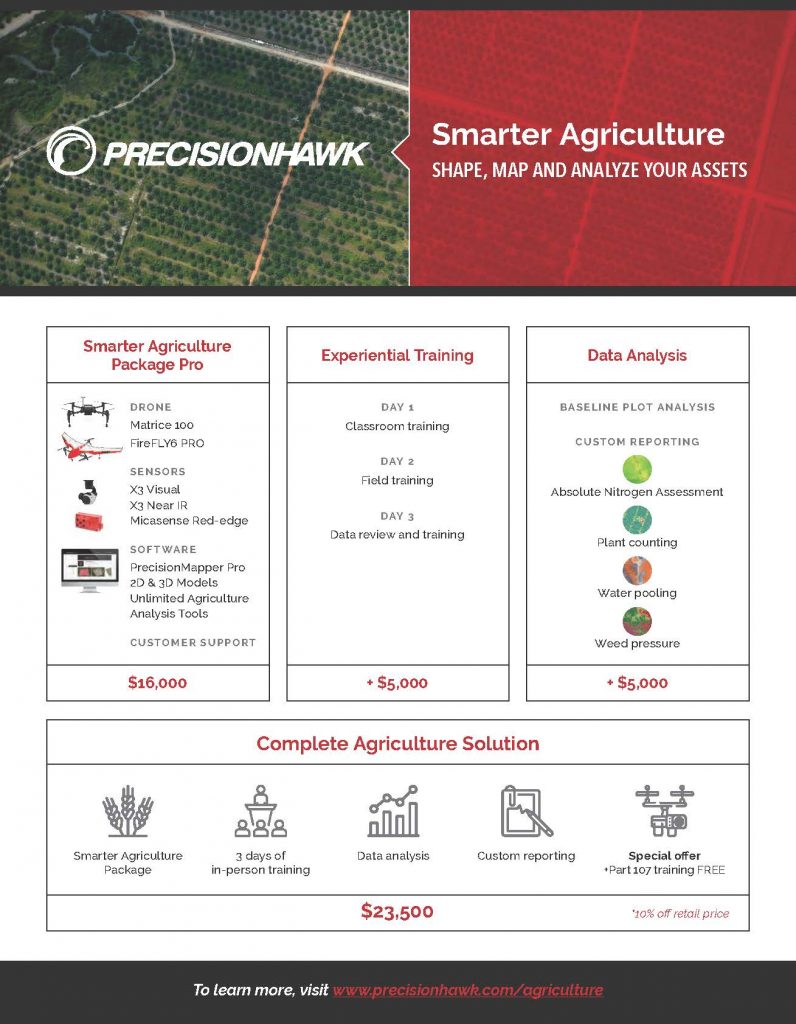
Smarter Agriculture Package Pro: Accelerate Field Monitoring Now
The FireFLY6 PRO is an ideal drone for agricultural professionals managing hundreds of acres of crops. It can be deployed from nearly anywhere and capture sensor data across large areas.
To help you make the most of the aerial imagery you capture with the FireFLY6 PRO, we’ve created the Smarter Agriculture Package Pro. In addition to the drone, the package includes visual, near infrared, and MicaSense RedEdge-M multispectral sensors. Also, you can produce unlimited 2D & 3D models, as well as run unlimited agriculture analysis algorithms with an annual subscription to PrecisionMapper Pro.
For an additional $5,000, we will come to you for three days of training. Also, we can conduct data analysis on your behalf for:
- Baseline Plot Reporting
- Custom Reporting, such as absolute nitrogen assessment, plant counting, water pooling, and weed pressure
For $23,500, you get all of the above at a 10% discount and free FAA Part 107 certification training.
 This growing season, capture more precise, timely, and accurate plant health and field data with the FireFLY6 PRO.
Speak with an agriculture expert about the the FireFLY6 PRO and the Smarter Agriculture Package Pro now.