In our eBook Beyond the Edge, you’ll learn about advanced drone-based sensing and four key sensors: thermal, multispectral, hyperspectral, and LiDAR. Read it now.
In this post, we’ve aggregated the key facts about hyperspectral sensing discussed in the book.
A New Perspective on the Electromagnetic Spectrum
 According to Jason San Souci, GISP, a Remote Sensing Scientist and GIS Strategy Expert: “When you investigate different portions of the electromagnetic spectrum, it’s like looking at the same subject matter under a completely different microscope. How that object interacts with incident light changes based upon the wavelength of energy, or spectral band, recorded.”
This is essentially the role of the hyperspectral sensor: to collect data as a series of narrow and contiguous wavelength bands providing a high level of performance in spectral and radiometric accuracy. You can use this detailed spectral information to identify subtle differences in vegetation, minerals and other materials.
This makes the sensor particularly useful to industries such as construction, insurance, agriculture, energy and government, which can use drone-led hyperspectral sensors to identify tree species and protect against yield loss through the early detection and identification of diseases.
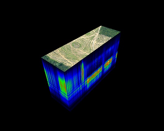
How Hyperspectral Sensors Work
Hyperspectral deals with imaging narrow spectral bands over a continuous spectral range, producing the spectral fingerprint of all pixels in the scene. A sensor with only 20 bands can also be hyperspectral when it covers the range from 500 to 700 nm with 20 bands each 10 nm wide. (While a sensor with 20 discrete bands covering the VIS, NIR, SWIR, MWIR, and LWIR would be considered multispectral.)
These sensors can detect and identify minerals, vegetation and other materials that are not identifiable by other sensors. They are used in plant nutrient status, plant disease identification, water quality assessment, foliar chemistry, mineral and surface chemical composition and spectral index research.
Hyperspectral sensors have two methods for scanning: Push Broom and Whisk Broom.
Push Broom scanning, which is ideal for drone use, captures full spectral data simultaneously as the drone moves forward using a line of sensors that runs perpendicular to the drone's flight direction. With this method, the scanner is able to look at a particular area for a longer period of time enabling more light to be gathered.
While, in the Whisk Broom method, a mirror scans the platform's path and light is reflected into a single detector, which collects data one pixel at a time. This method enables wide swaths of ground to be scanned and produces some pixel distortion.
Hyperspectral and Multispectral Sensors: Working Together
Hyperspectral sensors can also be used in tandem with multispectral sensors. Projects that involve hundreds of acres, for instance, are ideal opportunities for a sampling strategy that uses multispectral and hyperspectral sensing. Hyperspectral gives you better capabilities to see what you can't see with multispectral. It is for projects where you need discrimination power like identifying a specific disease impacting your crop and assessing severity levels. You can examine the entire project area using a multispectral sensor and then use the hyperspectral sensor to get a closer inspection on any areas that look different.
How to Collect Hyperspectral Data Using Drones
Regardless of how you collect hyperspectral data, whether it be by satellite, fixed wing or drone, processing and analysis of the data is the same. The only changing variable is temporal resolution, which is the amount of time between revisits to acquire data for the exact same location.
“The complexity of hyperspectral data makes it difficult to know whether you have captured quality data,” shared Jason San Souci, GISP. “Learning the tricks of the trade will give you an indication or reasonable level of confidence that the data is going to turn into a good product.”
While still in the field, be sure to preview and process the data using the specialized software created by the sensor manufacturer. You’ll be able to do a quick review of an RGB product (orthorectified data cube) to check for any issues such as distortion. Image processing and data analysis should take place back in the office using remote sensing software platforms such as Environment for Visualizing Images (ENVI) or MATLAB.
Redefine the Limits of Hyperpsectral Sensing
Organizations are overcoming a wide range of challenges by employing drone-based hyperspectral sensing. Like those pioneering the practice today, you have the opportunity to change the way your organization collects and uses data to solve problems.
To learn more about how advanced drones, sensors, and flight operations are redefining the limits of remote sensing, read our eBook Beyond the Edge. Or speak with an expert on our solutions team today.