PrecisionFlight, our autonomous flight solution, now provides commercial drone operators additional functionality to capture video data and mark specific frames to call attention to points of interest observed during a flight mission. This new technology enables DJI drone pilots or other on-the-ground observers to integrate video marking and tagging into their commercial remote sensing applications. And it’s all controlled in PrecisionFlight’s simple and intuitive user interface.
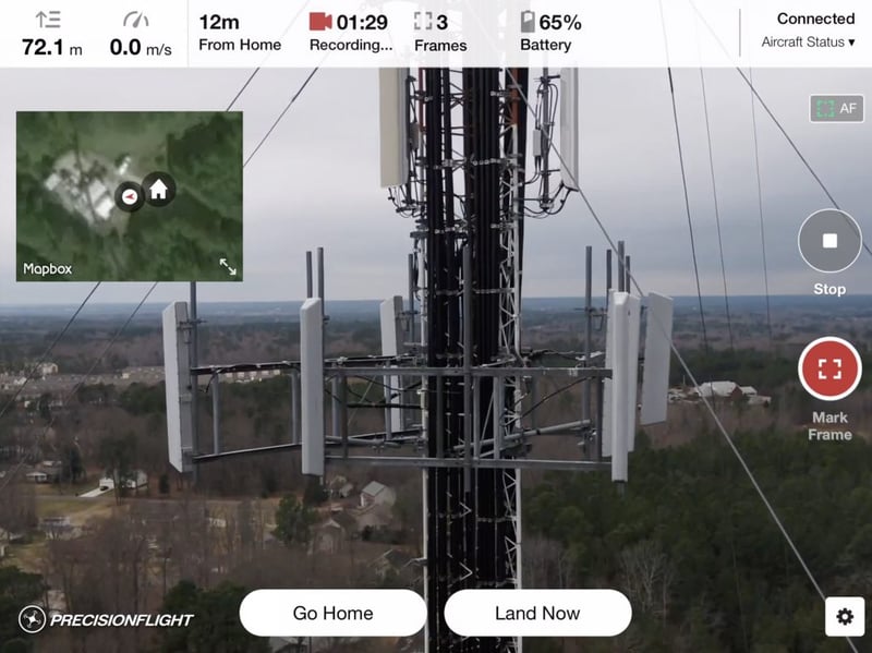 For example, a pilot inspecting cell phone towers could mark the frame where they observed a damaged antenna array.
“We’ve added another option alongside standard grid and orbit flights already available in the application,” says Ricky Hopper, Technical Lead of PrecisionFlight at PrecisionHawk. “By tapping an icon and swiping up to take off, PrecisionFlight users are instantly taken to the video recording interface where there’s a clear way to start the recording and mark any frames of interest during the flight.”
With PrecisionFlight’s new video feature, operators can see a real-time feed and mark specific frames as they see the video on their device. Experts and collaborators no longer need to review a separate frame list or be located at the survey site to review footage. As a result, PrecisionFlight helps businesses achieve faster drone-based inspection and cost savings.
Imagine a construction company working to develop a large tract of land that needs to document the site or show a team back at headquarters a potential problem. PrecisionFlight now provides video capture with frame marking for later review and analysis.
“Our platform is built to collect and analyze data from a variety of sensors.” explains Justin Gern, Director of Product Management for PrecisionMapper at PrecisionHawk. “Video is just one more type of data we now support.”
The application seamlessly integrates with PrecisionMapper, where drone operators and data teams can analyze video and other sensor data using a variety of specific algorithms. Uploading video and other sensor data from PrecisionFlight to PrecisionMapper is simple. Users can upload their video to PrecisionMapper, which will automatically match the video with their marked frames. They can then review the result at full resolution within their browser and share it with others.
“We’ve built a true end-to-end solution that people can use to simplify the complex,” says Hopper. “We’re helping people get usable data analysis in as few steps as possible.”
Insurance adjusters might use the new video feature when inspecting a house or building. They’ll be able to use the frame tagging feature to mark and log the point in the flight where they notice damage, yielding more robust information available to them upon analysis. This will result in a better claim analysis for their client.
“There are going to be even more use cases for this technology that we haven’t thought of yet,” says Hopper. “People are going to be able to use this technology to solve their own, unique problems—and that’s what we’re most excited about.”