Today, we’re excited to announce our newest aerial mapping, modeling, and inspection platform: PrecisionAnalytics.
With PrecisionAnalytics, you can apply the latest generation of AI to your aerial data, thereby automating analysis, streamlining reporting, and accelerating your work. Whether you’re inspecting thousands of well pads or hundreds of thousands of utility towers, with PrecisionAnalytics, you can reduce costs by up to 80% and dramatically improve safety in the field.
Using PrecisionAnalytics is simple: After a mission, drone operators upload data and imagery into the cloud-based system, which cross-references the uploaded imagery against thousands of terabytes of data, flagging issues. AI-driven machine vision then identifies aggregates the data into an intuitive, web-based analytics interface that’s accessible from anywhere.
The software’s flexible reporting and integration features even enable you to distribute information across your organization—whether it be exporting an Excel and Word document or integrating with other software, such as Enterprise Resource Planning (ERP) or asset management systems.
“By working closely capturing data on behalf of many clients, we’ve learned a tremendous amount about what they need to be successful. Our customers have consistently told us that they need a more efficient way to inspect their assets and analyze data. PrecisionAnalytics is that solution — utilizing advanced AI and machine learning to address the complexities of the energy enterprise,” said Michael Chasen, CEO of PrecisionHawk. “The results speak for themselves: drone-based aerial intelligence helps businesses reduce costs while improving the safety of their workers and insight into their assets.”

PrecisionAnalytics Energy consists of five distinct market solutions:
PrecisionAnalytics — Distribution
Ground teams via today’s traditional manner of inspection typically find that 10% of distribution poles are out of compliance. In contrast PrecisionHawk, on average, found that the number is typically between 25%-30%. PrecisionAnalytics Distribution is a cloud-based system that uses machine learning to automate the identification of distribution pole and component damage. It cross-references the uploaded imagery against distribution pole data and flags issues, producing a collection of imagery prioritized by asset health.
Learn more about PrecisionAnalytics Distribution
PrecisionAnalytics — Transmission
With PrecisionAnalytics Transmission, utilities can replace dangerous helicopter inspections, reducing inspection costs by up to 28%, and gain unprecedented insight into the condition of assets. The platform applies machine vision to identify areas of concern such as cracked insulators, corrosion or structural issues, and aggregates collected data to provide infrastructure statistics, vegetation maps, detailed views and historical record keeping. For one top 50 American utility, PrecisionHawk’s drone services increased the areas of concern identified by 42%.
Learn more about PrecisionAnalytics Transmission
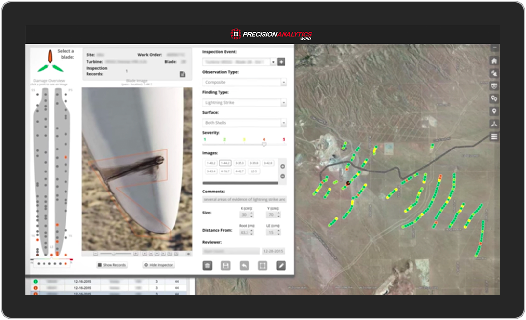
PrecisionAnalytics — Wind
Using PrecisionAnalytics Wind, some of the world’s leading turbine OEMs and servicers have reduced climbs—today’s traditional manner of inspection—by 50% and the cost of their inspections by 80%. PrecisionAnalytics Wind offers intuitive reporting features and AI-driven change detection that can identify issues such as leading-edge erosion, lightning strike damage, small cracks and wearing, gel coat degradation and UV radiation damage on an entire fleet or a particular blade. With PrecisionAnalytics Wind, turbine operators can reduce hazardous man hours, accelerate analysis, reduce time-to-value of data and increase uptime through preventative maintenance.
Learn more about PrecisionAnalytics Wind
PrecisionAnalytics — Solar
PrecisionAnalytics Solar can measure the condition of an entire fleet or a single module. With purpose-built machine learning, the platform detects issues such as cell-level defects, bad diodes, reverse polarity, storm damage, rack shifts and foreign objects. Users of PrecisionAnalytics Solar can integrate the solution with their existing asset management program, reducing the time required to conduct inspections—today, traditionally done by plane flyovers or by foot—by up to 90%, identifying up to 10 times as many issues and predicting future outages so that they can prioritize needed repairs.
Learn more about PrecisionAnalytics Solar
PrecisionAnalytics — Oil and Gas
Oil and gas supermajors are using PrecisionAnalytics to replace dangerous manned aircraft inspections with drone deployments and hours of tedious image review with machine intelligence, ultimately gaining unprecedented insight into the condition of critical assets. The solution offers leading thermal, infrared and LiDAR sensors, a methane detection laser and optical gas indicators that can capture asset conditions at a single point of time. With geospatial data that does not compromise the assets themselves, managers can integrate with existing enterprise resource planning systems, report their findings and take action.
Learn more about PrecisionAnalytics Oil and Gas
We’ve also updated our mapping and modeling offering for agriculture professionals:
PrecisionAnalytics — Agriculture
PrecisionAnalytics Agriculture is a powerful, but accessible, tool for turning aerial data into actionable intelligence. Using the software, farmers can process aerial data from multiple drone missions to identify and correct areas of concern before a planting season, during the growing season, or before harvest. The software features vegetative health indexing, plant and livestock counting, and tree crown sizing. Farmers can aggregate these measures into custom zones and plots before exporting prescription maps and other data sets into farm management systems. Ultimately, the technology is empowering a more accurate and holistic view of the farm.
Learn more about PrecisionAnalytics Agriculture

Talk to Us About PrecisionAnalytics
Contact us today to learn how you can use drone-based PrecisionAnalytics to protect the value of your investments and streamline your business operations.