
08.16.2021
According to the Institute of Electrical and Electronics Engineers, "The U.S. grid is showing signs of aging and, in some instances, is in need of replacement."
Utilities are taking action. One Top 10 American utility in the Southeast made a good deal of progress in its modernization program in 2019, after first using PrecisionHawk's GIS solution to discover and fix more than 17,000 errors in its database. And the N.C. Clean Energy Technology Center reports that 47 states (plus DC) took a total of 446 grid actions related to grid modernization in Q1 2020, "making it the busiest quarter yet since NCCETC began tracking grid modernization activity in 2017."
But as important as it is to maintain and update critical electrical infrastructure, many utilities are using inspection methods that result in inaccurate or inadequate data—like ground-only teams, paper checklists, and RGB photos taken from the ground—stalling their modernization efforts.
That's because if you don't know exactly what assets you have, where they're located, and what condition they're in, you can't modernize them.
Compounding the problem of outdated data collection methods, the databases many utilities use to track their assets make it challenging to verify, analyze, and report on the data that's in there. Errors in the database can cause utilities to miss assets that need to be optimized—and they can also cause costly derivations in capital project planning and O&M of assets.
ENRICHING CHECKLISTS WITH REAL-WORLD DATA
 Utilities need to be able to efficiently collect information, perform a delta analysis against their existing asset management system, and update the system with the correct data. Then, they need to analyze the now-correct data to determine the best grid-modernization actions to take. This requires a robust, streamlined workflow for data collection, processing, and analysis—one that can't be replicated with checklists.
A Top 10 American utility serves as a good example of how a well thought-out asset inspection workflow can improve and accelerate a modernization program.
The utility partnered with PrecisionHawk to inventory a portion of their 100,000 square miles of infrastructure after their incumbent provider failed to deliver results. PrecisionHawk helped the company build a geospatial technology and services portfolio tailored to their inventory requirements.
The portfolio spanned the data value chain, including drone- and ground-based data collection services and geographic information system (GIS) delta analysis:
- Drone crews used a tablet app to enter pole data, and a Bluetooth-enabled, portable GPS to automatically pull location data.
- They also flew a drone with stable hovering capability, featuring a high-definition RGB camera to capture crisp images from a variety of angles. The camera also tagged the photos with GPS coordinates and pole numbers.
- They then delivered data on a secure cloud storage and content delivery platform, including real-world RGB imagery, enriched by geospatial data furnished in XML and PDF reports. They also provided a flattened database file of all poles in each feeder.
With this workflow, utilities bring real-world information into the model world—and then that data is automatically processed, analyzed, and translated into real-world action.
GEOSPATIAL DATA, AMPLIFIED
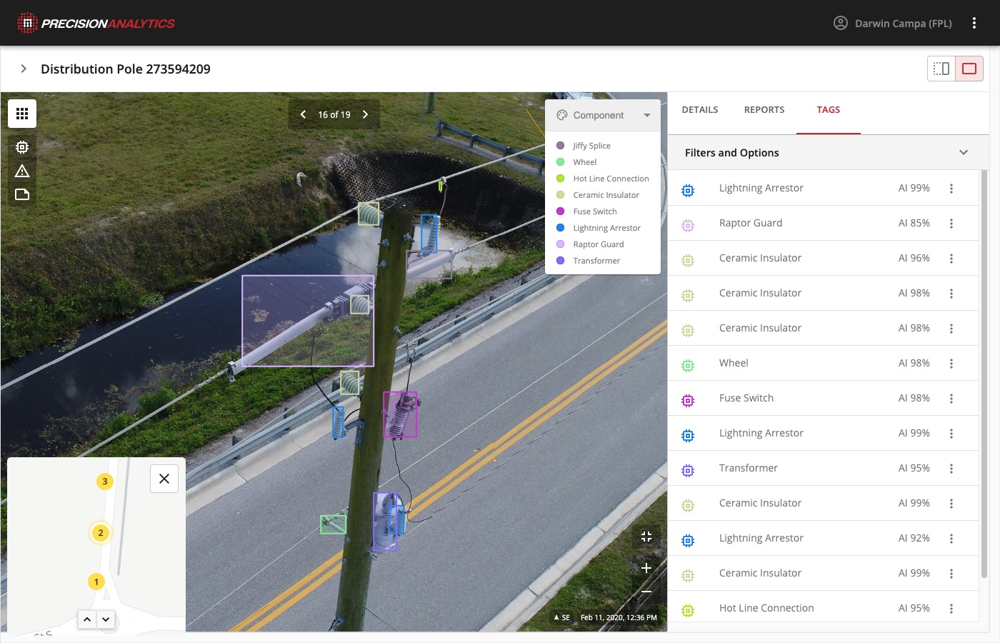 Utilities are further accelerating and automating this workflow by using PrecisionAnalytics Energy, the AI-powered analysis engine that accelerates and automates analysis of utilities’ asset data. After the AI’s machine intelligence identifies imagery that represents priority issues, it aggregates the data into an intuitive, web-based interface that's accessible from anywhere. With this information, a utility can quickly grasp what to tackle first in their modernization efforts.
That was the result for the Top 10 American utility that partnered with PrecisionHawk. The utility discovered 17,000 pieces of incorrect data in their database—including 1,500 errors in pole class and height data, 234 cases of missing poles where the utility thought it had one, and more than 500 existing poles that were not in the utility's database at all.
Using PrecisionHawk's geospatial data analytics services and tools, the utility was able to speed up the inventory process, gain unprecedented insight into the type and location of its assets, gather needed data on phasing—and make substantive progress in its modernization program.
Download our solution brief for details on how a streamlined workflow that includes AI and machine learning can help you accelerate your modernization efforts.